Plenty of south swell this week; looking very big on Friday

Sydney, Hunter and Illawarra Surf Forecast by Ben Matson (issued Monday 25th July)
Best Days: Tues/Wed: easing S'ly swell with good winds. Thurs: building S'ly swell /with good winds. Fri: large S'ly swell with good winds. Sat/Sun: smaller S'ly swell with good winds.
Recap: The last few days have generally played out as expected, with tiny surf Saturday followed by a building S’ly swell on Sunday from 2-3ft to 3-4ft across Sydney beaches, whilst the Northern Hunter built from 3-5ft to 4-6ft. Today we’ve seen stronger 4-6ft waves across the broader Southern NSW coast as a large pulse of S'ly swell filled in, with various offshore bombies and the Northern Hunter pulling in bigger waves around 6-8ft, which was a little bigger than anticipated.
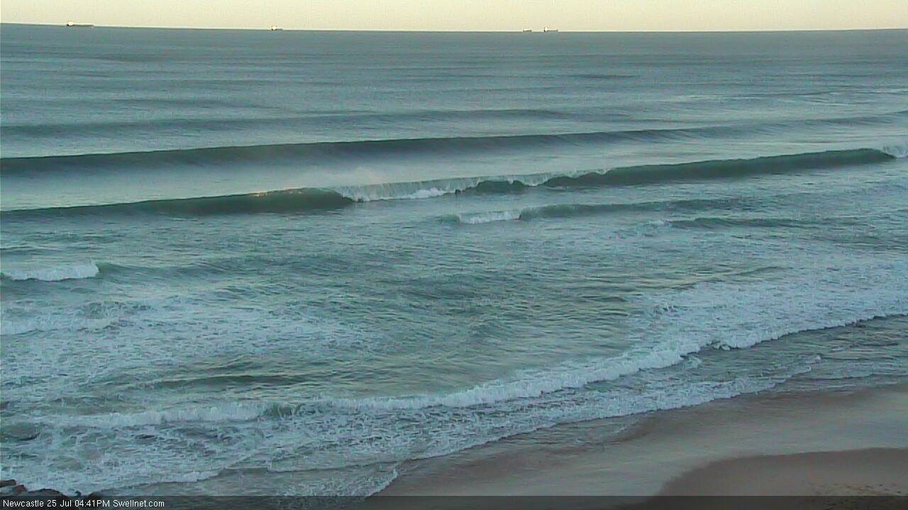
Ruler-edge lines at Newcastle this afternoon
This week (Tuesday 26th - Friday 29th July):
The low pressure systems responsible for the current swell has completely vacated our swell window. However, one final polar fetch that formed over the weekend at much lower latitudes will continue to supply good S’ly tending S/SE swell into Tuesday as the existing swell fades in size.
Regardless, we are still looking at an overall easing trend. South facing beaches in Sydney should still manage 3-5ft sets on Tuesday morning ahead of a decrease throughout the day, and the Hunter should still be quite solid with bombs in the 5-6ft+ range for the dawn patrol. As per usual, expect smaller surf at beaches not completely open to the south. Conditions should however be very clean with moderate to fresh W/NW winds. Surf size may lose two feet of more during the day (i.e. expect 2-3ft waves at south facing beaches mid-late afternoon).
The rest of the week is quite complex, with a series of back-to-back frontal systems expected to generate varying degrees of south swell. The broader storm track will remain quite ‘zonal’ (west-east) in alignment which reduces the confidence margin for wave heights, and it’ll also generate some large discrepancies in size across many parts of the region. But it’s a very active period nonetheless.
The first front, passing across Tasmanian longitudes on Tuesday, will only remain within our swell window for a short period of time. And it won’t be particularly well aligned either. The associated swell from this system is expected to glance the region later Tuesday - to be honest it may not be distinguishable from the pre-existing, easing S/SE swell anyway. Some small long period energy from the parent low (below Tasmania) may then follow through on Wednesday but I’m not expecting much more than 2ft+ at south swell magnets (bigger in the Hunter) and tiny conditions at most open beaches. The core fetch simply looks too unfavourably aligned for the Southern NSW coast, to generate any major size.
A weaker front is then expected to push up the Southern NSW coast on Wednesday, generating a short range S’ly swell that should kick up wave heights into Thursday morning. Our model is calling this at 3-4ft which I think is a minor overcall overcall right now; somewhere more around 3ft at south facing beaches seems plausible. However, if the fetch consolidates a little better by Wednesday’s runs we could be in for a small upgrade.
An extremely powerful low/front will then pass just south of Tasmania later Wednesday with surface winds up to 50-55kts. This system is once again not aimed very well in our swell window but there’s a decent north-east trajectory that’s better than previous frontal progressions, and the insane surface winds (and the width of the fetch) should compensate nicely.
The swell from this fetch is expected to reach the Far South Coast very late Thursday - possibly too late to be of any benefit - before pushing up into the Sydney region overnight. And it’ll deliver a large day of southerly swell for Friday; anywhere in the 5-6ft+ range at most south facing beaches, up to 6-8ft+ across outer bombies and up across the Northern Hunter.
In fact, I wouldn’t be surprised if we saw slightly bigger surf that this at reliable south swell magnets - the swell periods look really juicy (primary energy around 16 seconds) so right now there's a fair chance that this swell will overachieve, than underachieve. However if there's once concern, it's the forward speed of the storm - it does race off a little too fast through the lower Tasman to be optimal. If the models enhance this factor even to a small degree in later runs, it will probably pull back the size potential.
And, as per usual the acute southerly direction will once again result in much smaller surf at beaches with less southerly exposure. Let's wait and see what Wednesday's model guidance has for us.
As for local winds this week - most days are looking really good with some form of westerly breeze. Wednesday’s late front may swing winds to the W/SW or SW in the afternoon, but mainly along the South Coast. Otherwise elsewhere it’s looking like a glorious period of solid south swell and persistent offshore winds.
This weekend (Saturday 30th - Sunday 31st July)
Yet another series of trailing fronts behind the one responsible for Friday’s big swell will maintain plenty of southerly swell through the weekend. Though, it won’t be anywhere near as big or powerful as the last day of the working week.
It’s too early to pin down specifics, but at this stage, wave heights look like being somewhere around 3-4ft at south facing beaches both days (bigger in the Hunter), with light offshore winds.
I’ll fine tune this in more detail one the models have resolved the timing of these fronts a little better. But in short, we've got some fun surf expected this weekend.
Next week (Monday 1st August)
The models keep on spinning up Southern Ocean frontal systems into the long term. At this stage there’s no indication of any major swell event on the cards but it’s likely that we’ll see a continuation of revolving south swells into the indefinite future (i.e. most of next week), with generally favourable winds.
Not a bad run of winter waves at all, eh?
Comments
Who scored today? Looked amazing at some spots.
Crikey!
I surfed Cronulla Pt this morning Benny, it was good fun, a bit lully though
what an absolutely pumping day of waves!!!!!
first light in Newy was 4ft with 6-8 ft bombs every 20mins with lighter winds until approx 8-9am the wind hit it hard. Once the tide pushed in there 4-6ft smaller ones and 8-10ft even 12 ft bombs marching through until the tide started flushing out, last light was still 6-8ft solid!!!
What a day!
Hi Ben,
Have an option to go south coast or central coast for Friday to Sunday. Will south coast offer up the same, better or worse options than Sydney to Hunter regions?
Also, the models are saying 1-2 ft, and 2-3 ft at south facing beaches Friday and through the weekend? Quite a discrepancy. Am I looking at the wrong models? (eastern beaches, Wednesday through to Sunday)
Thanks
Absolutely firing yesterday, shame about the exposure though :(
Still very early to tell but WAMS are showing a massive run of swell from the 3rd August - 10th August.