April Retrospective

For the majority of the country, the past fortnight feels like Groundhog Day, both the surf and the weather.
A large, slow-moving high pressure system has been dominating the mid-latitudes resulting in relentless showers across the East Coast along with no true offshore breezes, while Victoria is seeing winds coming from the east rather than west.
But why is the high moving at a snail's pace from west to east?
It's thanks to a singificant split in the upper jetstream - which is the driver of our weather - on approach to the continent from the Indian Ocean. This split is diverting the upper level winds south and north of the country, and has been for the past week or two. In the absence of any upper levels winds between the split, high pressure can form and sit for as long as the jetsream remains split.

The current split jetsream (Weatherzone)
The reason for such a singificant split is unknown, but it's one piece of the puzzle regarding the current synoptic setup across the country.
The blocking high pressure has persisted into May, but there was surf a plenty in the weeks before, so let's have a look at the April just gone.
April was a varied surf month across the country. From abject flatness in the west to good to great waves on the Surf Coast and everything in between on the East Coast.
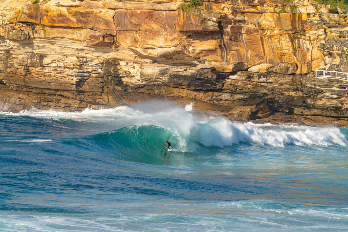
Moments of brilliance in Sydney (Gavin Vanderplank)
The Western Australian region went through what seemed like an impossible run of small to tiny surf with persistent offshore winds. Surfers living elsewhere may have seen some of it as the Margaret River Pro ran through the middle of the month. The southwest, which rarely goes flat, struggled to provide contestable surf for over a week before finally showing some form on the final day.
The Surf Coast came to life for the majority of April as a stationary node of the Long Wave Trough set up camp just east of Tasmania, steering and strengthening polar fronts swinging in under the country. While winds generally came to the party, it wasn’t all perfect with lots of southerly bouts thrown into the mix thanks to the track of the polar fronts up across Tasmania instead of arriving from the west, all thanks to the aforementioned slow-moving high pressure system sitting just west of the Bight.
The high was also the cause of WA's run of small waves, with it dominating the month as shown below in the Mean Sea Level Pressure anomaly (difference from long term average) chart for the month.

Mean Sea Level Pressure anomaly for April (NOAA)
That big red blob shows that pressure in the region was 12hPa higher than normal, quite a significant outlier for April and especially in that region, while the yin to the yang was the low pressure anomaly sitting south-west of New Zealand.
With winds spinning anti-clockwise around the high, we can see the high's blocking effect on Western Australia’s swell window, while also identifying the driver of persistent south swells for Victoria, South Australia, and Tasmania, along with smaller and inconsistent south swell for the East Coast.
One downstream beneficiary of this setup was Fiji, with endless days of swell roaring down the reef at Cloudbreak, with one such swell reaching the XL range.
The below chart, measuring the wind anomaly for April, depicts the general wind pattern succinctly.

Mean wind speed and direction anomaly for April (NOAA)
Looking at the East Coast more specifically, and the start of the month kicked off with a bang in southern regions thanks to a deepening coastal trough, come low pressure system which provided large surf out of the east-northeast, followed by four days of pumping south-east swell as the low deepened and moved slowly towards New Zealand.
South-east Queensland saw episodic pulses of localised trade-swell and long-range easterly energy, culminating in a steady diet of waves, punctuated by a couple of pumping sessions.
Down in Tasmania, the swell has been aplenty owing to the position of the southerly storm track, with numerous sessions seen at the deepwater slabs and more locally around the South Arm. Tassie's East Coast has generally performed OK but been patchy compared to other surrounding regions.
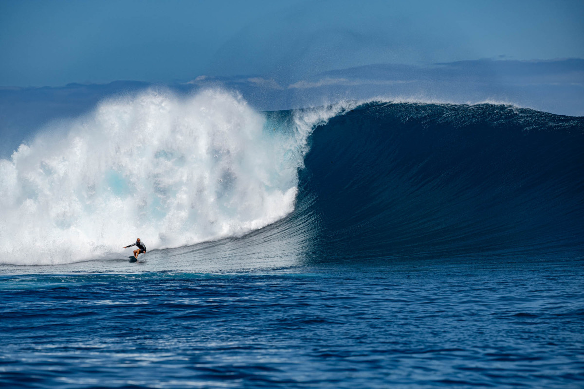
Jughead and a Cloudbreak bomb (Tony Harrington)
As we transitioned into May, the high pressure that dominated Western Australia has slowly shifted east, causing out of season east winds for the Surf Coast along with persistent rain and south-southeast winds across the East Coast.
Questions arise on when this pattern will break down and it appears likely to happen towards the end of the month, but there’s a couple of weeks between now and then. So settle in and learn to work around this stubborn pattern of surf and weather.
Comments
Not a fan of that last paragraph Craigo.
By far the worst summer\Autumn here on the Sunshine Coast in at least the last 30 years.Constant dreary rain also, it has sucked.
And after the last few atrocious Autumn's, that's saying something!
"One downstream beneficiary of this setup was Fiji". Sure was! Money set aside for the next one.
Yup it’s been shit, very mediocre ie opens onshore points quite small
A few glassy days at the opens but by no means offshore, just not onshore briefly
how about the choc water, ear infections and shit banks, I have been here 36 yrs and the last 2 years have been the worst by a mile
Benjis
What location are you
Same in the hunter,worst in many many yrs
5 months of easterlies is ENOUGH
Been a very average, to below average Autumn so far.
A scattering of quality but no decent runs of nice Autumn days.
Size has been down.
So many times, a coastal trough has looked to deepen into a classic surface low of some description only to get ripped apart by that jet stream.
Lots of days where onshore winds all night turn offshore before dawn but not enough to clean it up so you can surf lumpy, morning sick beachies or lumpy devil wind Points. Then the sou-easter is back by 8.30am.
This morning being a classic example.
Been good at the Superbank.
Hi Craig
Do think this could be having an effect on the the Indian Ocean Dipole and why its formed so early ?
It looks likely, with the persistent strong E/SE-SE winds off the north-west promoting a bit of upwelling. It's not the best wind for it along the north-west coast but with it being so persistent, the signal is there..
THANK YOU CRAIG.
it all makes sense now
No worries Clam!
For the rest of Oz that bags Vic weather it has been one sunny day after another. We seem to be the beneficaries of the current system as one part of April got proper cold (snow in the mountains) howere since has been sunny and light winds. Surf has been average, plenty of swell down the MP but banks have generally been poor.
Salute Craig for rather colourful Retrospective...
Never read or ever seen a Weather wrap taste so good...frothin' at the mouth...droolin' for more!
Weather God Craig : "SEQ saw Episodic Pulses of Localized Trade Swell and Long Range Easterly Energy, culminating in a steady diet of waves, punctuated by a couple of Pumping Sessions!"
tbb's Sarcophagus lid started reverberating...Strewth! That's Pretty powerful Stuff.
eHarmony Commissioner > "No Call of the wild!"...& "No Bongo Drums!"
No reawakenings & No Stirring of Emotions & No Comeback Special in the off season!" (bummer!)
Fair Play Rules of Engagement sportsmanlike Weather Reporting.
All things being Equal = April Anomaly...down 2 Earth explanation!
ENSO = Gearing down to Neutral
IOD = Gearing down to Neutral
SAM = Gearing down to Neutral
In periods where NO Weather force is dominant...(re: Groundhog Day)
Yesterday : ABC Weather Guy same as yesterday & will be same as tomorrow Oz wide...set'n'forget!
Q: Perfect breeding ground for supernatural weather anomaly or correction is more likely to occur?
Nothing Special...Nothing too much off the Charts...let's not get carried away.
No Climate Change devastation today... just some unexplained end of the World weather Anomaly!
A breath of Fresh Air...All say Aye...thanx for the Holiday we never knew we had to have Craig!
See that Gromz...Even our Weather Godz can over dramatize themselves...gotta luv that!
Motioning for Wizard like Cape & Wand for outlandish super stoked Weather God Craig.
In my opinion a sign of confirmed Global Warming. Highs getting bigger, sitting closer to the South, blocking the classic West / South West howlers we all knew and loved. I used to be able to set my clock to those cracking fronts. Poor Albatross'. Midnight Oil would struggle to write a song such as "Cold Cold Change" these days as we have ruined them. Am in SA and have not seen a skerrick of frontal activity in months and months.
Climate Action Now
Don't say that goodes... it's been my secret fear looking over the past few years that this will be the new normal... march april used to be the season of joy... now it's an extension of the usual crap summers. Putting up with summercrap is one thing... but watching my beloved Autumn turn to shit is entirely another matter... and one that can't be tolerated... what's to be done??
I tend to agree.
Not much swell for W.A, the only upside is perfect sunny warm days and pristine ocean conditions for months.
All the more reason to keep secrets..secret, no matter where you are.
To late for alot of places, but when the like an subscribe crews come a looking, remind them it's no exposure here mate.
Craig you need to do something about this... we need hope...
Great read Craig as usual. Explains a lot, particularly the lack of ECL development and sustained intensity which looks likely to be thwarted by the current jet stream? Now the canary in coal mine here is whether the jet stream is being directly affected by geomagnetic radiation from the current "Grand Solar Maximum" high sun spots (solar flaring) and the long term cycles of plantary alignment? Even the MSM has been acknowledging the recent flaring events.
https://www.abc.net.au/news/2024-05-10/bom-warns-level-g4-geomagnetic-st...
My own fascination here stems from the work of long range whether forecasters WD Gann and Inigo Jones, both of whom were renowned proponents of solar flaring being the main climate drivers for earth as part of long term cycles of planetary alignment which affect solar flaring. WD Gann in particular made millions in the 30's as a commodities trader with measured observations. Worst Autumn in recent memory here from Jervis Bay south. Cheers.
That's an interesting theory Gilligan. I've just learned about the geomagnetic poles and their influence on solar storms, I'm almost positive no one is yet publishing any possible influence on upper level weather impacts?
I wouldn't discount there being some small influence of these geomagnetic strikes on the atmosphere, but it doesn't have anything to do with the current setup.
The drivers are much more powerful and would have been in the works a month ago.
A split in the jet stream is quite significant and relates to the greater balance between cold/warm air from the poles and tropics, Rossby Wave trains etc. These take months to play out.
thanks for the homework assignment gilligan.
my own pocololo cloud may have risen the pressure on my wonder but to think the Relationships between sirius a, b and antares and our own solar system would not have some sort of effect on the gravitational waves and pressure.... it's a far out stretch of imagination but the more I study the more I fall asleep in time to wake up and go surfing even when it's onshore and fucked...
as far as I'm concerned its been uncrowded and fun if you look at the clouds and follow your nose.
I've found myself cursing any form of local wind forcast those. my condolances to the team. it's a tough time for computer guestimations.
Today is the 4th day in a row of all day offshore W/SW 3-4ft on the Coffs Coast.
I love your articles and pics Craig! Teaching us plebs
Love that shitney slab pic too! Legend
got an early forecast for chopes craig? the boys are itchingggg
Yep, today.
awesome, are they running a tahiti trials ?
A great animation of April and May so far..