Small, fading weekend with a large swell next week

Victorian Surf Forecast by Craig Brokensha (issued Friday October 27th)
Best Days: Today ahead of sea breezes, exposed beaches tomorrow morning, Monday morning Surf Coast for the keen, Tuesday morning, early Wednesday and Thursday Surf Coast
Features of the Forecast (tl;dr)
- Small, easing mid-period S/SW swell tomorrow with strengthening N/NE tending N winds, then N/NW later
- Small to tiny Sun AM ahead of a small increase in mid-period W/SW swell later PM
- W/NW-NW tending fresh SE winds Sun
- Easing W/SW swell Mon with fresh NW tending W/NW winds, strong SW into the PM
- Large SW groundswell building Tue with gusty W/NW tending strong SW winds
- Easing SW swell Wed with fresh SW-S/SW winds (likely early W/NW Surf Coast)
- Smaller Thu with moderate SW-S/SW winds (likely early W/NW Surf Coast)
Recap
Yesterday was a choppy mess across most of the state thanks to strong S/SW winds along with a moderate to large mix of S’ly swells.
The swell generating systems linked to the poor run of conditions and swell are now clearing to the east allowing winds to ease and conditions to slowly improve.
A moderate sized reinforcing S/SW swell from the polar front is keeping the size up today and conditions should continue to improve across all locations as winds tend variable ahead of SE sea breezes.
This weekend and next week (Oct 28 - Nov 3)
Like the evolution of the swell during the early week, we’ve got much better conditions due for the exposed beaches tomorrow but the swell will drop quite steadily, though not as abruptly as seen through Monday/Tuesday.
The polar front linked to today’s swell was slow moving and we should still see 2ft sets tomorrow morning on the Surf Coast, though fading through the day and 3ft to the east.
Winds will kick up quickly though, being strong from the N/NE, shifting more N’ly through the day and N/NW late.
An overnight change will quickly shift back to the W/NW-NW on Sunday morning but with a low point in swell. The front linked to this temporary change is generating a small pulse of mid-period W/SW swell for Sunday afternoon and Monday morning.
A late pulse to 2ft is expected on the Surf Coast with 3-4ft sets to the east but with fresh S/SE sea breezes, with a peak overnight, though Monday will likely see 2ft to occasionally 3ft sets to the west, and 3-5ft to the east but with fresh NW offshore winds, shifting W/NW through the morning ahead of a shallow W/SW change.
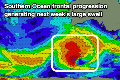
This shallow change will be linked to the head of a broad, strong Southern Ocean frontal progression moving in from the west, with it forming to the south-southwest of Western Australia tomorrow.
This progression is now looking quite healthy with a fetch of gale to severe-gale W/SW-SW winds moving through our south-western swell window, with a little sling-shot push helping to produce a large SW groundswell for Tuesday.
The Surf Coast looks to come in at 6-8ft when it peaks into the afternoon, 8-10ft to the east and with favourable morning W/NW winds, shifting strong SW into the afternoon SW-S/SW on Wednesday with early W/NW winds around Torquay.
Similar but weaker winds are due into Thursday as the swell continues to ease, with some reinforcing swell likely late week. We’ll have a closer look at this on Monday. Have a great weekend!