Strong swells as far as the eye can see

Victorian Surf Forecast by Ben Matson (issued Wednesday April 24th)
Features of the Forecast (tl;dr)
- Large, generally wind affected surf Thurs
- Large, steadily improving surf Fri with lighter winds
- Great waves all coasts all weekend with light winds and slowly easing surf
- Another large swell Tues but winds look iffy
- Plenty of activity into the longer term too
Recap
Fun waves persisted on Tuesday with offshore winds for much of the day, and slowly easing swells from 2-3ft to 2ft in Torquay, bigger around 3-5ft east of Melbourne ahead of the easing trend. Strong onshore winds kicked in behind a cold front this morning, bumping up building swells that are now pushing 4-6ft west of Melbourne and 6-8ft east of Melbourne.
(Please note: FC Notes will be variable in delivery this week as Craig is on paternity leave)
This week (April 25 - 26)
No change to the outlook for the next few days.
Today’s surf should hang in at a similar size tomorrow, perhaps down a notch in Torquay but still arounds the 4-5ft+ mark, with 6-8ft surf early of Melbourne (and small waves inside sheltered spots).
However, we’ll still be under the influence of post-frontal SW winds, and they will deliver similar conditions as per today.
We should see the wind ease along the Surf Coast overnight and revert to a brief light W’ly around dawn, but even if local conditions start to clean up - which I’m 50/50 on - there’ll still be a considerable wobble through the lineup from today’s blow. And, the early light pattern won't last very long at all, so keep your expectations in check.
Friday has a stronger S/SW groundswell on the cards, from another polar low developing south of the continent over the last day or so.
This will rebuild size back up into the 5-6ft+ range along the Surf Coast (6-8ft+ east of Melbourne) but the good news is that the SW flow will have eased considerably by this time so we should see a longer period of light W tending W/NW winds in Torquay, which will allow conditions to improve a few notches from Thursday (still not perfect, mind). East of Melbourne should see very good waves across the sheltered bays and coves.
As a side note, keep in mind that this swell will peak through the afternoon, so surf size may be marginally undersized early morning. Winds will probably swing SW throughout the mid-late morning and may freshen into the afternoon, but it won’t have too much strength.
This weekend (Apr 27 - 28)
Very nice conditions are expected on all coasts this weekend with light variable winds and weak sea breezes both days.
Friday’s large surf will slowly ease back from 4-5ft to 3-4ft on Saturday west of Melbourne (6-8ft easing to 5-6ft east of Melbourne) before levelling out around 3ft+ and 4-5ft respectively on Sunday.
This should offer a diverse range of waves pretty much everywhere, though the sheltered bays and coves east of Melbourne will quickly become undersized so you’ll have to aim for an early session on Saturday maximise your surf potential.
Next week (Apr 29 onwards)
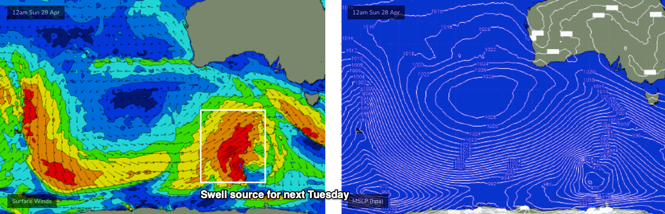
A strong polar low and front will develop well SW of the continent on Thursday and Friday, and power through our prime SW swell window over the weekend (see below), generating a powerful new groundswell that will arrive on Tuesday morning, and build to 5-6ft+ in Torquay, with 6-8ft sets east of Melbourne.
However, local conditions are looking a little average under the influence of moderate southerly winds associated with a large developing high pressure system to the west, which may dampen enthusiasm levels somewhat. Either way it’s a cracking swell to keep an eye on over the next few days.
And.. the Southern Ocean storm track looks like it'll remain vigorous for some time, so the surf outlook is very favourable for the first half of May.
See you Friday!
Comments
sick!
That looks good. This is more like the Autumn that I used to know.
will the forecast notes be a bit later in the day for the forseeable future? your page clicks will be going through the roof with people expecting the early forecast notes
I've had a disclaimer in the FC Notes above for the last week and a half: "Please note: FC Notes will be variable in delivery this week as Craig is on paternity leave".
Normal programming will resume next week.
And just on the topic of page clicks.. it's a meaningless metric, we don't generate extra revenue when the forecasts are late (remember, FC Notes are subscriber-only, so there are no ads).
Not sure what the models were smoking earlier this week Ben but so far this instalment of forecast notes has overblown swell heights by near double.
In what way, plops? Yesty was 4-5ft in Torquay, and there are 5-6ft sets today.