Strong S/SW groundswells on the way with east winds

Victorian Forecast by Craig Brokensha (issued Wednesday May 8th)
Best Days: Today, tomorrow ahead of sea breezes, Friday ahead of sea breezes, selected spots Saturday, Tuesday exposed beaches
Features of the Forecast (tl;dr)
- Moderate sized S/SW groundswell for later this afternoon with variable winds, easing tomorrow with E/NE-NE winds ahead of sea breezes
- Smaller Fri AM, ahead of another late pulse of S/SW groundswell, peaking Sat AM
- Moderate E/NE tending NE winds ahead of sea breezes Fri
- Strong E/SE winds Sat
- SE windswell for Sat, easing Sun with small levels of fading S/SW swell
- Fresh E/NE tending variable winds
- Small W/SW swell Tue with N tending variable winds
- Moderate levels of mid-period W/SW swell for later next week onwards
Recap
The exposed beaches to the east continued to provide the best surf through yesterday with a good 4ft of swell, smaller and to 2ft+ on the Surf Coast.
This morning we’ve got smaller surf and similar conditions, though a strong new S/SW groundswell is due into the afternoon as winds tend variable. More on this below.
This week and next (Apr 9 - 17)
This afternoon’s pulse of S/SW groundswell will be worth keeping an eye out for, especially with the favourable, variable winds expected into the evening.
The source was a strong polar low firing up to our south-southwest earlier in the week and we should see the Surf Coast pulsing to 3-4ft on dark today, easing from a similar size tomorrow morning and 4-6ft to the east.
Winds tomorrow will be favourable again and E/NE-NE through the morning ahead of weak sea breezes.
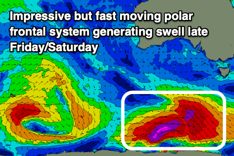
The swell will back off temporarily into Friday morning ahead of the next pulse of S/SW groundswell through the late afternoon and Saturday morning.
The polar storm linked to this swell will be a little stronger but fast moving and more distant. With this I feel we’ll see a similar peak in size to the first swell, coming in at 4ft on the Surf Coast Saturday morning and 5-6ft to the east.
Conditions should be good again Friday morning with a moderate E/NE tending NE breeze ahead of sea breezes, with Saturday not coming in as favourable thanks to a strong E/SE’ly breeze. This will only favour selected locations and also kick up some SE windswell on the Surf Coast.
Sunday will be better with a fresh E/NE tending variable breeze but smaller, easing surf from a peaky 2ft on the Surf Coast, 2-3ft to the east.
The surf will bottom out into Monday with a shift in winds to the west as a weakening mid-latitude low slowly moves in from the west.
This low will generate some small mid-period W/SW energy for Tuesday, with the size likely to come in at 2ft+ max on the Surf Coast and 4ft to the east.
Winds look N’ly through the morning, variable into the afternoon, offering OK waves for the keen.
Looking longer term and there’s a flurry of frontal activity inbound through next week but the strength and structure seems to fall apart, leading to moderate levels of mid-period energy.
Winds look favourable for the Surf Coast at this stage with the swell arriving from next Thursday onwards. More on this in Friday’s notes.
Comments
Craig we have had great weather a classic autumn set up for Melbourne yet up north it hasn't stopped raining. It always seems to be the way: wet up north, dry down south and vice a versa.
Regular autumn programming will resume next week