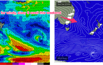
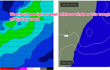
An angled trough of low pressure forms off the NSW Coast o/night and quickly moves out into the Tasman Sea. Compared to Wed’s notes windspeeds look a smidge weaker, but the fetch forms a better aligned SE arm around the trough line through Sat.
Primary tabs
/reports/forecaster-notes/sydney-hunter-illawarra/2024/05/17/strong-run-s-se-swells-ahead-windows
freeride76
Friday, 17 May 2024

/reports/forecaster-notes/sydney-hunter-illawarra/2024/05/15/nice-settled-days-end-the-week-wild-and
freeride76
Wednesday, 15 May 2024
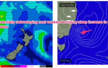
Strong winds to potential S’ly gales look to develop o/night Fri into Sat as the low pressure trough deepens offshore and a strong high moves into the Bight.
/reports/forecaster-notes/sydney-hunter-illawarra/2024/05/13/easing-swells-week-sizey-windy-s-swell
freeride76
Monday, 13 May 2024
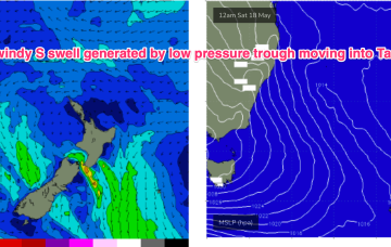
Small swells from this low will ease through the week with some deep polar activity sending more small S swell wrap up the Pipe before a stronger frontal intrusion this weekend brings a sizier S swell with plenty of S wind.
/reports/forecaster-notes/sydney-hunter-illawarra/2024/05/10/swells-various-sources-over-the-weekend
freeride76
Friday, 10 May 2024
Mixed in with that will be a nice little boost in E-E/SE swell from fetches on the NZ side of the Tasman, holding into Sun, likely even increasing a notch from a broad fetch of winds infeeding into the developing low pressure trough.
/reports/forecaster-notes/sydney-hunter-illawarra/2024/05/08/still-bit-iffy-better-outlook-the
freeride76
Wednesday, 8 May 2024
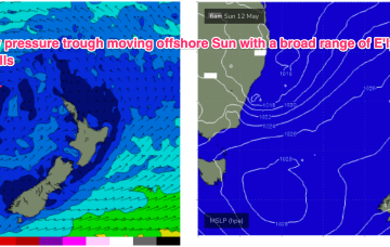
The resulting high pressure ridge is leading to deep onshore flows and a trough along the coast is expected to move offshore Sun and form a broad trough of low pressure early next week. That should see improved conditions north of the low pressure trough.
/reports/forecaster-notes/sydney-hunter-illawarra/2024/05/06/another-week-onshore-se-winds-few
Another week of onshore SE winds with a few favourable windows around rain squalls and troughy areas
freeride76
Monday, 6 May 2024
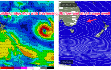
In fact, it becomes reinforced by a new high and this peanut high straddling Tasmania will hold a firm ridge along most of the Eastern Seaboard with another working week of SE-E winds, gradually backing off into the weekend. A stalled trough looks to linger off the coast bringing plenty of unstable weather and possibly windows of lighter winds.

/reports/forecaster-notes/sydney-hunter-illawarra/2024/05/03/periods-lighter-winds-in-the-rain-se
freeride76
Friday, 3 May 2024
Monster high pressure has barely budged since Wed, maintaining a S-SE flow right up the Eastern Seaboard, with a coastal trough ensuring plenty of unstable, rainy weather.
/reports/forecaster-notes/sydney-hunter-illawarra/2024/05/01/extended-run-s-se-winds-still-ahead
freeride76
Wednesday, 1 May 2024
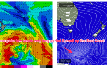
A storm force polar low is better aimed at Pacific targets but we’ll still see some long period S groundswell from it this weekend, with the proviso that S’ly winds will remain persistent.
/reports/forecaster-notes/sydney-hunter-illawarra/2024/04/29/stubborn-high-in-the-bight-brings-se
freeride76
Monday, 29 April 2024
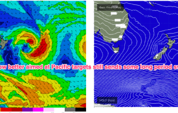
Later polar fronts in the far southern/central Tasman remain strong and although better aimed at Pacific targets we’ll still see some significant sideband S’ly energy from them.
/reports/forecaster-notes/sydney-hunter-illawarra/2024/04/26/improving-conditions-over-the-weekend
freeride76
Friday, 26 April 2024
Things get interesting/dynamic from Tues. At issue is a trough and potential surface low in advance of a major high pressure ridge.