Indonesia/Maldives forecast May 2

Indian Ocean Basin analysis by Craig Brokensha (issued Thursday 2nd May)
This week through next (May 3 - 10)
The strong swell seen on the weekend and early week is now slowly easing across the region, though buffered by a reinforcing pulse of energy today.
Expect the size to continue to ease into tomorrow, bottoming out on Saturday.
Now as touched on in Tuesday’s update, we should see the forerunners of a large, long-period SW groundswell arriving through Sunday, kicking strongly late ahead of a peak on Monday.
It’ll be inconsistent but we should see strong 8ft sets across magnets Monday, with 6-8ft surf across most other breaks, easing slowly from Tuesday, further into Wednesday and Thursday morning.
The easing trend will be slowed a touch by a reinforcing S/SW swell Tuesday, generated by off-axis, severe-gale W/NW winds trailing the low generating the large groundswell.
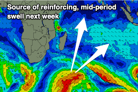
Our moderate sized, mid-period SW swell for late Thursday and Friday is on track, with it being generated by a broad but relatively weak polar front projecting up into the Indian Ocean today, south-east of Madagascar.
Following this the outlook is slower until the following week, but more on this Tuesday.
Looking across to the Maldives and the focus is on the incoming S’ly groundswell pulses, with an inconsistent, fun increase due tomorrow afternoon ahead of our large, strong swell Saturday, peaking into the late afternoon.
There’s no change to the expected size and small levels of background SE trade-swell should be in the water from today through all of the coming period.
The polar frontal progression currently pushing north through our swell window will generate a reinforcing, moderate sized + S’ly swell for Wednesday, easing Thursday.
On a final note it looks like we're heading for an early positive Indian Ocean Dipole mode, and we all know that that means.. More here: https://www.swellnet.com/news/swellnet-analysis/2024/05/02/indian-ocean-dipole-event-set-arrive-early
Eastern Indonesia:
Easing swell over the coming days.
Long-period SW groundswell forerunners arriving late Saturday, building more so through Sunday, reaching 6ft by later and peaking Monday to 8ft on the magnets, 6-8ft most other spots.
Slowly easing swell Tuesday and Wednesday.
Moderate sized, mid-period SW swell building late Thursday, peaking Friday to 4-5ft.
Fresh to strong E/SE-SE trades, light and variable each morning. Weaker, moderate trades into next week.
Uluwatu 16-day Forecast Graph/WAMs
Western Indonesia/Mentawais/South Sumatra:
Easing S/SW groundswell for the coming days.
Long-period SW groundswell forerunners arriving late Saturday, building more so through Sunday out of the S/SW, reaching 8ft on dark across the magnets (6-8ft most spots), easing from a similar size Monday morning.
Moderate sized mid-period S/SW swell for Thursday to 4-5ft+, easing from a similar size Friday morning.
Variable winds, strengthening from the W/NW-NW through Monday afternoon/Tuesday, then easing but persisting from the NW.
Mentawai 16-day Forecast Graph/WAMs
Maldives:
New S’ly groundswell building late Friday to 3-4ft across the southern atolls, with a larger pulse Saturday to 6-8ft into the late afternoon, easing from 6ft+ Sunday.
SE trade-swell building Friday to 3ft+, holding through the weekend, back to 3ft next week.
Reinforcing S’ly swell for Wednesday afternoon and Thursday morning to 4-6ft across the southern atolls.
Moderate W/SW-W winds tomorrow and Saturday, strengthening Sunday afternoon but more so into next week.
Comments
Latest notes are live.