Large S/SW groundswells inbound, tricky working the winds

Victorian Surf Forecast by Craig Brokensha (issued Friday April 5th)
Best Days: Keen surfers Sunday, Monday Surf Coast, Wednesday morning Surf Coast, Thursday morning Surf Coast, Friday Surf Coast
Features of the Forecast (tl;dr)
- Large S/SW groundswell building tomorrow PM with easing E winds, freshening from the E/SE into the PM
- Easing swell Sun with moderate S/SE tending S/SW winds
- Smaller Mon with freshening W/NW winds ahead of an evening SW change
- Moderate + sized mid-period SW swell Tue with fresh S/SW winds (possibly light W early)
- Easing swell Wed with W/NW tending fresh S/SW-SW winds
- Large S/SW groundswell building Thu with S/SW-SW winds, likely W/NW early
- Easing S/SW swell Fri with W/NW tending SW winds
Recap
Wednesday's increase in swell held into yesterday with bumpy, onshore conditions across most spots, workable for the keen.
This morning we've got more size as a new pulse of mid-period SW swell peaks, but a fresher south-east wind is creating lots of chop and bump on the Surf Coast, cleaner to the east in selected spots.

Chunky sets this AM
This weekend and next week (Apr 6 - 12)
This morning's pulse of mid-period SW swell is due to ease into this afternoon, smaller tomorrow morning and back to 3ft or so on the Surf Coast, 4-5ft to the east.
This will only be a temporary drop, with a strong pulse of S/SW groundswell due to arrive through the morning, building towards a peak into the late afternoon/evening.
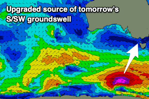
The source of this groundswell was a strengthening fetch of gale to severe-gale W/NW winds moving under the country, though a stronger low pressure developed, with storm-force winds recorded at its core.
This will bump the swell into the large size range, with the Surf Coast now due to reach 6ft later tomorrow, 6-8ft on the sets to the east, easing Sunday from 4ft and 6ft respectively west and east of Melbourne.
Looking at the local winds, and strong overnight E-E/SE winds are due to abate into tomorrow morning, tending moderate E'ly, freshening again into the mid-afternoon from the E/SE.
Sunday looks dicey as the low drifting down the East Coast pushes further down past Tasmania, bringing moderate S/SE winds that are expected to shift S/SW through the afternoon and freshen later.
Monday is still looking clean on the Surf Coast with a freshening W/NW offshore along with a further drop in size. The Surf Coast should still be around 3ft, with 4-5ft sets to the east, with winds likely holding until dark, ahead of a fresh SW change.
This change will in its earlier stages, by a good swell generating frontal system, with it forming just east of the Heard Island region today.
A healthy fetch of strong to near-gale-force W/NW tending W winds should generate a moderate + sized pulse of mid-period SW swell for Tuesday, coming in around 4-5ft on the Surf Coast and 6ft+ to the east.
Unfortunately, beside a possible period of early W'ly winds on the Surf Coast, fresh S/SW winds look to make a mess of the swell, with more of a chance for an early W/NW breeze due Wednesday as the size eases.

For the rest of the week and next weekend, further pulses of moderate to large S/SW groundswell are due as a series of strong polar fronts fire up to the south-west of Tasmania, under the influence of a strong node of the Long Wave Trough moving across the southern Tasman Sea.
The first pulse of S/SW groundswell is due Thursday, peaking into the afternoon, likely to 6ft on the Surf Coast and 6-8ft to the east but with persistent S/SW-SW winds (W/NW likely early as the swell builds).
Friday morning looks the pick at this stage with a W/NW offshore and with 4-5ft of easing S/SW swell.
Another large pulse is due Saturday but we'll have to confirm this on Monday as the models diverge a little. Have a great weekend!
Comments
thank you for your blessings Craigos!
Hey Craig, what are you reading into size predictions that other forecasts aren't?
Wouldn't all of that information be contained above?
Looks like the switch has finally been flicked to Autumn on the Surf Coast. Swell and Westerly quadrant winds. Hopefully a few NW days some time soon too.