Lots of quality surf days to come

Victorian Surf Forecast by Craig Brokensha (issued Friday April 12th)
Best Days: Today, tomorrow, Sunday, Monday, Tuesday morning
Features of the Forecast (tl;dr)
- Moderate + sized reinforcing S/SW swell for later this afternoon with S/SW winds, easing tomorrow
- Moderate W/NW winds tomorrow AM, tending S/SW into the PM
- Moderate sized mid-period S/SW swell for later Sat, peaking Sun AM then easing slowly, further Mon
- W/NW-NW tending variable winds Sun and Mon (late S/SW change to the west)
- Large mid-period SW swell building Tue, peaking in the PM but with early W/NW tending fresher S/SW winds from late AM
- Swell easing Wed with light-mod S/SW tending S/SE winds
Recap
Our large S/SW groundswell peaked yesterday morning with the Surf Coast coming in around 6ft under light to moderate onshore winds. It wasn't great but workable with better conditions into the afternoon as winds settled along with the tide.
This morning is smaller but cleaner with good 4ft sets on the Surf Coast with offshore winds, larger to the east but lumpy and not great.
This weekend and next week (Apr 13 - 19)
The current easing trend in swell from yesterday will be halted by the arrival of a good, mid-period S/SW swell into this afternoon.
This was generated by a trailing polar front on the backside of the low linked to yesterday's swell, but later in our southern swell window.
This will see the Surf Coast provide similar sized waves to locations further east, thanks to the shadowing effects of Tasmania.
The Surf Coast magnets should kick to 4-5ft later this afternoon with 4-6ft sets to the east (as winds go S/SW) easing into tomorrow morning, back from 3-4ft and 4ft+ respectively west and east of Melbourne.
Winds look good for the Surf Coast again tomorrow morning, light to moderate out of the W/NW, shifting S/SW but without much strength into the afternoon.
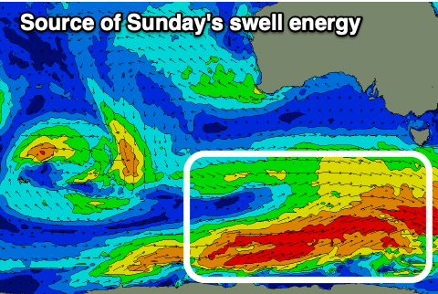
Later in the day we've got our new pulse of mid-period S/SW swell due, with it expected to peak Sunday.
This is being generated by patchy but healthy fetches of strong to gale-force W/SW winds along the polar shelf, south-west of Tasmania, and should come in around a consistent 4ft on the Surf Coast, 5-6ft to the east, easing slowly into the afternoon and further Monday back from 3ft+ and 4-5ft respectively.
Winds on Sunday morning look W/NW-NW, tending variable into the afternoon, with Monday now due to play out similarly with winds unfortunately not going north enough for the beaches to the east.
We're expected to see a late afternoon S/SW change Monday and with this, the next pulse of strong SW swell for the region Tuesday.

The source of Tuesday's swell will be a deepening polar low, south of the country on the weekend, with a slow moving and broad fetch of W/SW gales due to generate a large mid-period SW swell. It's due to fill in through Tuesday and peak into the afternoon, reaching 5-6ft on the Surf Coast and 6-8ft to the east, easing back slowly Wednesday from 4-5ft and 6ft+ respectively.
Winds now look better for Tuesday morning and W/NW for a period, shifting S/SW and freshening during the day.
Less favourable S/SW tending S/SE winds are due on Wednesday as a high moves in from the west, though they might be light enough to see a local land breeze kick in. We'll review this Monday.
This looks to be the final pulse of strong swell energy for the current period, with slower surf expected into the end of the week and end of the month. Therefore make the most of the current and coming swells! Have a great weekend.