Fun weekend of waves; solid but windy early next week

Western Australia Surf Forecast by Ben Matson (issued Friday April 19th)
Features of the Forecast (tl;dr)
- Fun weekend of waves in Margs with building swells and generally good winds
- Small surf on the metro beaches, best Sunday
- Solid but windy surf Mon/Tues
- Back to small conditions for the back half of next week
Recap
Very small surf on the metro beaches with clean conditions. Very small surf early Thursday built with a new swell into the afternoon, offering 3ft+ sets before peaking today around 4-5ft. Early morning E/NE winds veered NE then N/NE through the middle of the day, with NW winds reported this afternoon at Cape Leeuwin but NE winds reverting back at Cape Naturaliste.
(Please note: FC Notes will be variable in delivery this week as Craig is on paternity leave and Steve is covering Margs)
This weekend (Apr 20 - 21)
The weekend’s winds look pretty good across both coasts.
Light morning offshores across the metro beaches will precede moderate afternoon sea breezes. Down south, Margs will see a similar pattern on Saturday as per what we saw today, but with less strength, and a delay in the swing to the north. This should allow for a longer period of favourable conditions through the morning.
Sunday has an approaching SW change on the way but the latest model guidance has shunted it back to mid-late afternoon, so we should see clean conditions for the most part with light offshore winds tending variable through the middle of the day (note: variable means ‘from any direction’, which could be onshore, though I don’t think it’ll gather much strength until later on).
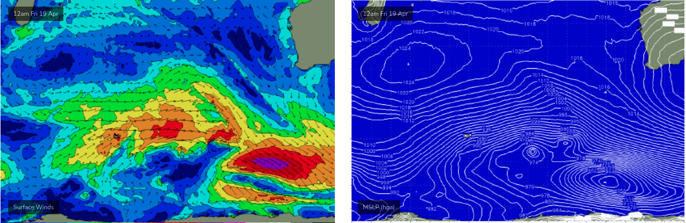
As for surf, we’re at the start of an active phase of overlapping swell trains, sourced from a conveyer belt of fronts pushing through the Southern Ocean this week, with size expected to peak across the WA coast early next week.
It needs to be reiterated that these kinds of swell patterns are tricky to estimate the precise surf size at specific times of the day, because at any one point in time there could be a wide combination of new/building swell, existing/peaking swell, and old/easing swell - of which the response of different swell directions and periods across the local bathyetry profile always results in different surf sizes. Patience is a strong requirement when waiting for optimum surf conditions.
So, painting in broad brushstrokes for now, Saturday morning will be the low point in the current cycle, though we should see fluctuating pulses in and around the 4-5ft mark across exposed breaks in the Margs region throughout the day. Expect only small 1-2ft surf across Mandurah and 1ft+ in Perth.
An upwards trend is likely through the afternoon and into Sunday, where we should see bigger surf pushing 5-6ft across Margaret River for most of the day (sourced from the front below), and I’m reasonably confident that there’ll be a period of a few hours - perhaps in the morning - where we see a few bigger bombs north of 6ft to maybe 6-8ft.
Another characteristic of overlapping swell trains is that it tends to increase the perceived consistency in the surf zone too, which will be very welcome at the WSL event.
Across metro beaches, Sunday’s looking better for surf prospects with fun 2-3ft surf expected in Mandurah and 2ft surf in Perth, which may punch a little higher for a few hours too (as mentioned above).
Next week (April 22 onwards)
A peak in swell energy is then expected through Monday and Tuesday with the Margs region likely to be more consistently 6-8ft+, however gusty S’ly tending S/SE winds are expected across the region as a broad high ridges in from the west.
We’ll see similar conditions throughout the metro beaches, with a chance for an early period of lighter SE winds around Perth, and peaky surf around 2-3ft with bigger sets across the Mandurah stretch. Expect average conditions in general though under the sideshore breeze.
The dominant high pressure system responsible for these gusty winds will also act as a synoptic blocking feature for the long term, steering approaching frontal systems to the south along the ice shelf, and thus returning the state back to a period of small surf sourced from distant storms.
With some luck this block will break down mid-late next week, allowing a return to stronger surf patterns the following weekend and beyond.. But that’s still quite some time away.
Have a great weekend, see you Monday!
Comments
Thanks Ben. Any notes available for Indo next week?
Looks like it’s going to be a case of 0 - 100 for my first Margaret River surf..