Average surf this week, improving on the weekend

Western Australian Surf Forecast by Craig Brokensha (issued Monday April 29th)
Best Days: Perth and Mandurah Saturday morning, Sunday morning all locations, Monday morning in the South West, Tuesday morning in the South West, Wednesday morning
Features of the Forecast (tl;dr)
- Easing SW swell tomorrow with strong, but easing E/NE tending NE winds
- Tiny Wed/Thu with strong NE tending N/NW winds Wed, gusty N/NE tending NW winds Thu
- Large SW swell building Fri, peaking overnight with strong W-W/NW winds in the South West, variable tending W/SW to the north
- Larger, inconsistent W/SW groundswell building Sat, peaking later, easing Sun
- Gusty S/SW winds across the South West Sat, S/SE tending S/SW Sun (SE tending SW in Perth and Mandurah Sat/Sun)
- Easing swell Mon with S/SE tending S/SW winds
- Moderate + sized W/SW swell building Tue with E/NE tending SW winds
Recap
Average surf on Saturday with some new swell into Sunday offering lumpy but decent 3-5ft sets in the South West, 1-2ft across metro locations.
Today is smaller but cleaner across the South West, tiny to the north.
This week and weekend (April 30 – May 5)
Our current swell is expected to continue easing through tomorrow as winds clock around to the E/NE, thanks to a strong high pressure cell sliding in and under the state, into the Bight.
With this we'll see any major local storms deflected away from the state, resulting in the swell bottoming out into Wednesday and Thursday.
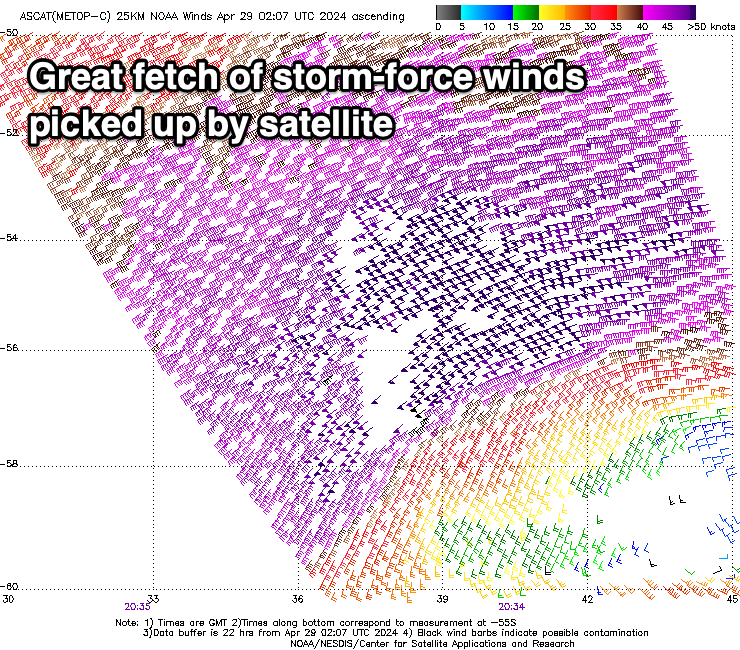
Looking further afield, and our significant swell producer the weekend is on track, with a strong frontal progression forming south of South Africa on the weekend.
We're seeing a great fetch of severe-gale to storm-force W/SW winds projected towards us, with a large, long-period W/SW groundswell due from this source late Friday but more so Saturday, peaking into the afternoon. Margaret River should reach 10ft with 2-3ft sets across Mandurah and 2ft+ waves in Perth.
Ahead of this though, a close-range SW swell is due to build Friday, thanks to tight, intense low forming off our coast on Thursday (below). A slow moving fetch of W/SW-SW gales should generate a spike in size to 6-8ft across the South West later in the day, 2-3ft in Mandurah and 2ft in Perth but with strong W-W/NW winds (weaker W/SW to the north) thanks to the close proximity of the low.

Cleaner conditions should be seen across the Perth and Mandurah on Saturday as the long-period groundswell arrives, with gusty S/SW winds persisting across the South West.
Winds should swing back to the S/SE on Sunday as the groundswell eases back in size, dropping from 6-8ft in the South West, 2ft or so to the north.
Similar winds with smaller surf is due into Monday, with the next pulse of energy due to arrive through Tuesday out of the W/SW. It looks to be moderate + in size with more favourable winds but we'll take a closer look at this Wednesday.
Comments
Hey Craig
thanks for the ongoing forecast always part of my weekly reads and has got me on some good waves in the balance of commitments and surf planning.
Swell direction - I use to help select spot, this however seems more hit and miss than size and wind. Take yesterday, predicted bit of south in swell 215ish swell direction then the reality of margs naturaliste coast had more west I would guess at 230ish as can be seen on real time buoy - is this just the fickle nature of predicting swell direction, the bathemetry or what?
thanks PK
Good question, and a tricky one to answer in short.
But yeah, bathy, period etc can swing a SW swell more W/SW as shown on the buoys when it moves close to shore, when at other times it will come in true to expectations. There's also shifts in directions thanks to local currents etc. A lot at play.